UTAFITI MBALIMBALI KATIKA DINI NA SAYANSI
IMEANDALIWA NA AL-AMIN ALI HAMAD
UCHAMBUZI WA AYA ZINAZOHUSIANA NA ELIMU YA GEOLOGY (ELIMU YA ARDHI)
Nimeweka Picha mwisho wa Utafiti ili habari hizi zieleweke vizuri zaidi.
Katika Elimu ya Ardhi inayojulikana kama Geology. Tunasoma kwamba Milima ni kama Vigingi vya Uso au Gamba la Ardhi.
Mfano wa Vigingi hivi ni sawa na Misumari. Kwa lugha rahisi Milima Ni Misumari kutoka Uso au Gamba la Ardhi na kuishia katika Tabaka linalofuata la Gamba la Ardhi linalojulikana kama Lithosphere.
Kama nilivyozungumzia katika Mlango wa “BLOGS ZA SAYANSI”” za Website hii kwamba Ardhi imegawanyika katika Matabaka Saba.
Wataalamu wamegawanya Matabaka ya Ardhi katika Migawanyiko mbalimbali ili kurahisisha Kuielezea na Pia kwa kutegemea Maudhui inayokusudiwa kuelezewa.
Kuna Wenye kuigawanya katika Migawanyiko Mikubwa Minne kama Vile Inner Core, Outer Core, Mantle na Crust. Lakini ukichambua Matabaka ya Migawanyiko Mikubwa utaikuta imegawanyika Tena katika Migawanyiko Modogo Midogo kama vile Lithosphere na Asthenosphere.
Kwa kifupi migawanyiko mikubwa na midogo ni Saba na inalingana na Kauli ya Mwenyeezi Mungu alivyosema katika Kuruani kwamba Matabaka ya Ardhi ni saba mfano wa Mbingu ambazo pia ni matabaka saba.
Kwa hiyo kazi za milima ni kuidhibiti Ardhi isiyumbeyumbe.
Sayansi inatufundisha kwamba Tabaka la Kwanza katikati (ndani) ya Ardhi ni Chuma na Tabaka linalofuatia ni Chuma iliyoyayuka, na baada ya Hapo inafuatiwa na Matabaka Mengineyo ambayo yanaelea juu ya Chuma hii iliyoyayuka na mwisho Tabaka ambalo tunalijua ni Gamba La Ardhi au Earth Crust, tabaka Hili ni miongoni mwa Matabaka Mengineyo chini yake ambayo yote yanaelea katika Chuma Iliyoyayuka.
Na kwa vile Uso au Gamba la Ardhi halikuungana kama vile Yai lilivyo bali limegawanyika katika Mapande makubwa Saba na Vipande vinginevyo vidogo vidogo karibu kumi ambavyo yote vinaelea kama vile Merikebu au Meli ilivyo juu ya Bahari.
Angalia hapa chini Mapande Makubwa na Madogo yanayojulikana kama Major na Minor Plate Tectonics, na ukubwa wake kwa vipimo vya Square Kilometres.
1 Pacific Plate Major 103,300,000 sq km
2 North American Plate Major 75,900,000 sq km
3 Eurasian Plate Major 67,800,000 sq m
4 African Plate Major 61,300,000 sq m
5 Antarctic Plate Major 60,900,000 sq m
6 Indo-Australian Plate Major 58,900,000 sq m
7 South American Plate Major 43,600,000 sq m
——————————————————-
8 Somali Plate Minor 16,700,000 sq km
9 Nazca Plate Minor 15,600,000 sq km
10 Philippine Sea Plate Minor 5,500,000 sq km
11 Arabian Plate Minor 5,000,000 sq km
12 Caribbean Plate Minor 3,300,000 sq km
13 Cocos Plate Minor 2,900,000 sq km
14 Caroline Plate Minor 1,700,000 sq km
15 Scotia Plate Minor 1,600,000 sq km
16 Burma Plate Minor 1,100,000 sq km
17 New Hebrides Plate Minor 1,100,000 sq km
Mwenyeezi Mungu ametoa mfano mzuri na kufananisha Milima na Mawingu yanavyoelea Hewani.
Mwenyeezi Mungu akasema katika Sura Ya Al-Nnaml Namba 27 Aya namba 88 kwamba
وَتَرَى ٱلۡجِبَالَ تَحۡسَبُہَا جَامِدَةً۬ وَهِىَ تَمُرُّ مَرَّ ٱلسَّحَابِۚ صُنۡعَ ٱللَّهِ ٱلَّذِىٓ أَتۡقَنَ كُلَّ شَىۡءٍۚ إِنَّهُ ۥ خَبِيرُۢ بِمَا تَفۡعَلُونَ (٨٨)
88.Na unaiona milima unaidhania imetulia;nayo inakwenda kama mawingu (yanavyokwenda).Ndiyo sanaa ya Mwenyezi Mungu, (matengenezo yake) aliyekitengeneza kila kitu; bila shaka anazo babari za yote mnayoyatenda.
Ukisoma Namna Mawingu yalivyo. Yanavyojiunga na Kutengana, Kuzidi ukubwa na kupungua, Kupotea na Kuzuka, na Elimu nyinginezo za Mawingu utashangaa kuona kwamba Ni sawa sawa na Milima kwani ina sifa mfano wa mawingu.
Aliyetuumba na kuumba kila kitu anatupa Sayansi ya hali ya Juu ambayo haiwezekani Mtume Mohamad ﷺ ambaye alikuwa hakusoma kuweza kuzungumza Elimu kubwa kama hii. Haiwezekani Kabisa.
Milima pia Inakaribiana na kutengana, kuzidi na kupungua ukubwa, kuzuka na kutoweka kama vile Mawingu.
Mwenyeezi Mungu hakukosea hata kidogo Yaliyopo katika Kuruani na hakika tunazozisoma.
Kwa mfano Kuna Aina Tatu Ya Milima na majina yake yanatokana na namna Ya milima hiyo inavyozuka.
Fold mountains, Fault-block mountains, na Volcanic mountains.
Fold Mountains ni Milima ambayo asili yake ni Kugongana kwa Sahani au Pande za Miamba ya Ardhi na kusababisha Kilima hapo katikati palipogongana mapande hayo. Unaweza kufanya Jaribio kwa kukutanisha Vitabu viwili na utaona unapozidisha Nguvu kuvisukuma vitabu hivi viwili Baadhi ya Makaratasi yak kuibuka juu na hivyo ndivyo Vilima vinavyoanza kukua.
Fault-Block Mountains ni Milima mabayo asili yake ni wakati Mapande ya Masahani au Miamba ya Ardhi yanapokutana na kusuguana (siyo kugongana na kusukumana) na Pande moja kupanda juu ya lingine na kulizamisha chini katika ardhi. Kufanya hivyo kutasababisha kusukuma Juu Baadhi ya Udongo na kuanza kukua na Kuwa Mlima baada ya Muda.
Volcanic Mountains ni Milima ambayo inazuka kutokana na Mrenda wa Miamba chini ya Ardhi ulioyayuka kwa ajili ya joto kali ambao unatoka chini ya Ardhi na kububujika juu kupitia katika Ufinyo au finyo za Ardhi. Mrenda huu unapotoka juu na kupigwa na upepo hukauka na kuwa Mlima.
Kuna Aina Mbili ya Milima ya Volcanoes:
Ya kwanza ni Kububujika kwa Mrenda wa Magma juu ya Ardhi na kukauka juu yake.
Na aina Ya pili ya milima inyojulikana kama Dome Mountains ambayo Mrenda wa Magma kuganda chini ya Ardhi na kusababisha Miamba juu yake kuvimba na kuwa Mlima.
Kwa kawaida Elimu ya Geology inatufundisha kwamba Mapande ya Uso wa Ardhi yanapokutana na Kusukumana Basi lile pande lililo na ukubwa na nguvu litalisukuma lile pande dhaifu chini yake na litaendelea kukua Juu yake na kusukuma Udongo, Mawe na Kila kitu Kilichopo juu yake na hatimaye kusababisha Kuzuka kwa mlima.
Tunasoma pia kwamba Milima inaleta usalama kwani ni sawa na Spring au Sponge kuzuia Mapande hayo yasigongane gongane na kusababisha Kuyumba yumba na Ndiyo maana Mwenyeezi Mungu akasema katika Aya ya Kuruani kwamba Milima ni Kama vile Vigingi. Na ukifikiri utaona Kwamba ni kweli kwani Ukichunguza Kazi ya Vigingi katika Ujenzi mfano wa hema ni kulidhibiti lisiyumbeyumbe kwa hewa na kuangushwa, ba pia Mvua au chochote kitakachokiyumbisha basi hivyo hivyo Milima inakuwa kama Vigingi vya Gamba la ardhi isigongane gongane na kuyumbisha kila kinachoishi juu yake.
Mwenyeezi Mungu anasema Katika Sura Ya Al-Nahl Namba 16 Aya Namba 15.
وَأَلۡقَىٰ فِى ٱلۡأَرۡضِ رَوَٲسِىَ أَن تَمِيدَ بِڪُمۡ وَأَنۡہَـٰرً۬ا وَسُبُلاً۬ لَّعَلَّڪُمۡ تَہۡتَدُونَ (١٥)
15.Na akaweka katika ardhi milima ili (ardhi)isiyumbeyumbe nanyi. Na (akaweka) mito na mabarabara ili mpate kuongoza (njia mnazozitaka) na pia anasema
4/Sura Ya Ambiya Namba 21 Aya Namba 31
وَجَعَلۡنَا فِى ٱلۡأَرۡضِ رَوَٲسِىَ أَن تَمِيدَ بِهِمۡ وَجَعَلۡنَا فِيہَا فِجَاجً۬ا سُبُلاً۬ لَّعَلَّهُمۡ يَہۡتَدُونَ (٣١)
33.Na tukaweka katika ardhi milima (yenye kuthubuti barabara katika ardhi) ili isiwayumbishe,na tukaweka humo mabarabara, wazi-wazi ili wapate kuongoza njia.
Angalia Sayansi ya Kuruani inavyojieleza. Kwa njia rahisi na yenye kueleweka.
Jambo lingine ningependelea kulizungumzia ni Zile sehemu za Nchani za Mapande au Sahani za Ardhi ambazo zinasukumwa ndani ya ardhi.
Mapande hayo yanapozamishwa basi huzama na hatimaye kuyayuka kwa joto kali na Yakawa kama vile Mrenda unaojulikana kama Magma.
Huu ndiyo mrenda unaoweza kupanda na kumiminika Nje ya Gamba la Ardhi kwa mchakato wa Volcano na Baadaye kukauka Juu ya ardhi na Kuitwa Milima.
Kwa hiyo Mipaka au Ncha (Edges au Boundaries) za Vipande hivi ambavyo vinazamishwa na kugeuka kuwa Mrenda wa Magma Huenda ndivyo Aya ifuatayo ya Kuruani inaviashiria Mwenyeezi Mungu anasema.
5/Sura Ya Arrad Namba 13 Aya Namba 41
أَوَلَمۡ يَرَوۡاْ أَنَّا نَأۡتِى ٱلۡأَرۡضَ نَنقُصُہَا مِنۡ أَطۡرَافِهَاۚ وَٱللَّهُ يَحۡكُمُ لَا مُعَقِّبَ لِحُكۡمِهِۦۚ وَهُوَ سَرِيعُ ٱلۡحِسَابِ (٤١)
41.Je! Hawakuona kwamba tunaifikia ardhi yao (makafiri), tunaipunguzapunguza katika mipaka yake? Na Mwenyezi Mungu huhukumu (kwa uadilifu) na hakuna wa kupinga hukumu Yake. Naye ni mwepesi wa kuhisabu.
Sayansi inasema kwamba Sehemu ya Mapande ambayo yanapunguka kwa kuzamishwa chini ya Ardhi (Subduction Zone) yanajulikana katika Sayansi kama Plate Boundaries Katika Mchakato unaojulikana kama Convergent Plate Boundary. Yaani mkutano wa Sahani ya Ardhi na Mojawapo kuizamisha nyingine na kuipunguza urefu.
Mwenyeezi Mungu anasema hapa kwamba Tunaipunguza Ardhi katika Mipaka Yake.
Hii ndiyo Mipaka Ya Ardhi. Na ndiyo maana neno أَطۡرَافِهَاۚ yaani “Boundaries” ni Plural yaani Boundaries zaidi ya moja. Na neno au kitendo hiki kipo katika Present Tense. Ni kitendo Kinachoendelea na siyo kilichopita.Yaani Milima ipo katika kuundwa na kupotea kama vile Mawingu. Hii ni mojawapo ya Tafsiri.
Kuna Kauli nyingine inayosema kwamba Pande zinazopunguzwa ni North na South Pole ya Dunia Kauli hii inathibitishwa na Umoja Wa Wanasayansi huko America (NASA) inatuelezea kwamba Equatorial Radius Ya Ardhi ni 6378,5 km, Na Radius Ya Polar ni 6357 km. Tofauti ya Asilimia % 0,3. Upungufu huu unaendelea kila mara na siyo mara moja peke yake. Na ndiyo maana Ardhi haipo Duara bali kama Yai. Sababu iliyotolewa ya kupungua kwa Ardhi katika sehemu North na South Pole ni kasi ya Mzunguko wa Ardhi kwa kujizunguka yenyewe katika Masaa 24 ya kila siku.
Kuna Kauli ya Tatu inayosema kwamba Ardhi yote inapunguapungua kwa kugongwagongwa na Meteriorite zinazoanguka Kutoka hewani na pia Mzunguko wake wa kasi wa kila siku
Kwa kweli Mwenyeezi Mungu ndiye mwenye Kuitunza na kila kitu alichokiumba kwani kuna Mapande ya Miamba ambayo yanaangukia Ardhini kutoka Angani kama vile Meteorite ambayo yafidia upungufu wa Ardhi inayopungua.
Na hivi ndivyo mwenyeezi Mungu alivyojaalia Kuweka Mizani katika Dunia. Ardhi haipungui uzito au ukubwa hata ikamwezwa na Jua na haizidi uzito ikasababisha Force ya Gravity ya Jua isiwe na Nguvu na ishindikane kuishika Ardhi. Hii inathibitisha kwamba kwani kiumbe kimeumbwa kwa vipimo vya hali ya juu na kwa hekima kubwa sana.
Milima inapopungua Urefu kwa Kupigwa na Upepo au Mvua basi inapungua uzito na kuzidi urefu kwani Chini yake zile sahani zinasababisha Milima Kukua na hivyo hivyo unapozidi uzito unaigandamiza Lithosphere na kuzama zaidi katika Ardhi. Sayansi imezungumzia Elimu hii na kuiita “ISOSTACY” ni njia mojawapo Mwenyeezi Mungu alivyojaalia Milima Kudhibitiwa.
Milima inapozidi urefu basi urefu wake ni mdogo sana na huwezi kuuuona kwa masiku machache bali kwa muda mrefu kama vile mwaka.
Milima kama vile Himalaya Huzidi urefu kiajabu sana Kwani zile Sahani au Plate Techtonics bado zipo katika Kuminyana. Moja iipo juu ya Nyingine na Inaendelea hivyo na kusabanisha Milima kuendelea kukua Centimetres Moja kila Mwaka.
Tumesoma kwamba Sahani au Mapande ya Ardhi YanayumbaYumba Na kuelea Juu ya Chuma iliyokuwa Molten (Iliyoyayuka) iliyopo Ndani ya Ardhi kama vile Mrenda wa Moto.
Nadharia Ya Mtaalamu aliyejulikana kwa jina Alfred Wegener Aligundua Kwamba Asili ya Ardhi hapo awali ilikuwa Matabaka au Masahani yaliyokaribiana sana lakini Utafiti wake hakuweza kujua Sababu iliyofanya Kuyumba yumba kwa sahani hizi. Baada yake Wataalamu waligundua mengineyo ambayo yalisaidia kutanua Nadharia ya Wegner. Baada ya Utafiti wa Alfred Wegener na Utafiti nyinginezo Mbalimbali sasa tunapata kuelewa zaidi Elimu hii ya Plate Tectonics na Drift of Continents.
Na Kama tulivyoelezea kwamba Masahani au Mapande ya Tabaka la ardhi (Plate Tectonics) ) yanayumba yumba na kwa ajili hiyo hutengana na kuna sehemu nyingine hukaribiana na hukutana.
Karibu miaka 335 Milioni iliyopita mpaka leo Baadhi ya Masahani ya Ardhi yanaendelea kutengana na pia kuna yale ambayo yanakaribiana kwani Mapande haya ya Miamba yanyaumbayumba katika kila upande. Kuyumbayumba huku ni kwa kiasi kidogo sana na sisi hatuhisi au kuona chochote.
Sahani hizi hutengana na kusababisha Rift Valleys kama vile huko East Africa na Nyinginezo duniani
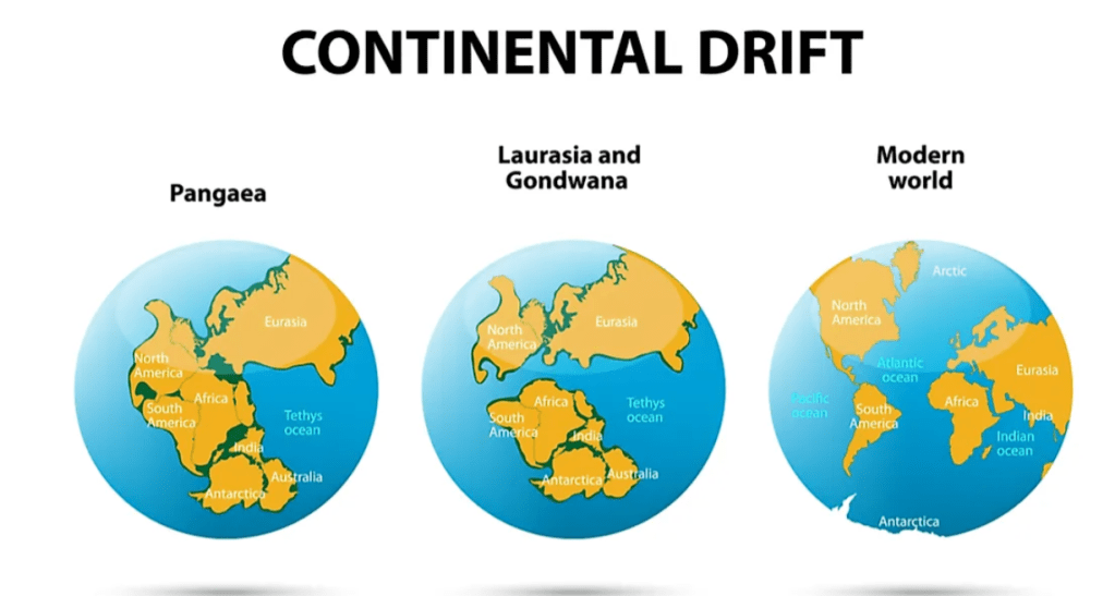
Na kutengana huku kumeigawanya Pangea na Pia Panthalassa katika Mabara (Continents) na Mabahari (Sea and Oceans) mbalimbali.
Utafiti wa Mimea, Wadudu, Wanyama na Mifupa katika sehemu zinazokabiliana uso kwa uso zinafanana na zinathibitisha kwamba Bara au Continents zote pamoja na Mabahari yalikuwa karibu sana.
Na hata Maumbile ya Bara au Continents ukiyaunganisha basi yatavalishana kama nguo. Ukiangalia Umbile la America ya Kusini utaona zile sehemu za pwani zinazoelekeana na pwani ya Africa zilikuwa zimeungana na Africa na baadaye kutengana.
Na hivyo hivyo Bara nyinginezo zilikuwa zimeungana.
Ukiangalia Ramani utaona haya ninayoyazungumza.
Utafiti huu na mengineyo tuliyoyazungumza inathibitisha kwamba aliyeshusha Kuruani ndiye yule yule aliyeumba ulimwengu au Malimwengu. (zaidi ya Ulimwengu mmoja).
Elimu hizi za leo zinathibitisha haya. Allahu Akbar. Angalia Aya za Kuruani zinavyoelezea na kutufundisha Sayansi za hali ya Juu.
Mtaalamu wa Kijerumani aliyejulikana kwa jina kama Alfred Wegener alizaliwa mwaka 1880 na kufariki dunia mwaka 1930. Mtaalamu huyu ndiye aliyekuja na nadharia ya Kuyumbayumba kwa Continents za Dunia. Nadharfia yake haikukubaliwa kirahisi ijapokuwa alikuwa na Ushahidi mkubwa. Hakuweza kuelezea kwa nini Matabaka au Masahani ya Gamba bla Ardhi yaliweza kuyumbayumba au Kufanya Movements yeyote ile. Utafiti wake haukueleweka vizuri mpaka baada ya Miaka Hamsini (Nusu Karne kupita) Je unaona Maajabu? Alizungumzia Habari hizi mwaka 1950 alipochapicha Nadharia hii. Sasa Kuruani inazungumzia Habari hizi kuanzia Karne ya 7. Je Mtume ﷺ alifanya Utafiti gani wakati huo? Yaani wakati huo kulikuwa hakuna Elimu kama za leo. Allahu Akbar. Unaona Miujiza?
Sehemu hii ni nimeizungumzia kwa kiswahili hapa juu. hakuna Jipya.
PLATE TECTONICS-DRIFT OF CONTINENTS
Pangea was once a single unified landmass surrounded by a solitary sea called Panthalassa. Pangea broke apart in three major stages, as rifts appeared within the Earth’s crust. It is estimated that Pangea was formed some 335 million years ago.
Nearly 300 million years ago, the geography of the Earth was drastically different than it is today. This time period, between 280 million and 230 million years before present, was known as the late Paleozoic to early Mesozoic Era, and it was during these periods that Earth consisted of one collective ocean, called Panthalassa, and one single land mass or supercontinent known as Pangea. This name stems from the Greek word ‘pan’ meaning all or whole, and Gaia which refers to Mother Earth.
It is estimated that Pangea was originally formed some 335 million years ago, but was perhaps not the first or only continental form. Likely, this continental formation was created from the coming together of other continents and land masses on Earth. This can be assumed in part due to the fact that continents and tectonic plates – large plates of the Earth’s crust that make up the surface of our planet – are constantly in motion, drifting apart or butting together. This process is continually happening, it just occurs at such a slow rate by human terms, that we do not see any significant shifts in a human lifetime, or even in the history of humans in general.
The Earth is divided into three main layers. The dense, hot inner core (yellow), the molten outer core (orange), the mantle (red), and the thin crust (brown), which supports all life in the known universe.It is so hot that the metals inside are all in the liquid state. The outer core is located around 1800 miles under the crust and approximately 1400 miles thick. It is composed of metals such as iron and nickel.
1/Fold mountains – Fold mountains are formed when two plates run into each other or collide. The force of the two plates running into each other causes the Earth’s crust to crumple and fold. Many of the world’s great mountain ranges are fold mountains including the Andes, Himalayas, and the Rockies.
2/Volcanic mountains – Mountains that are caused by volcanic activity are called volcanic mountains. There are two main types of volcanic mountains:
Volcanoes and Dome mountains.
Volcanoes are formed when magma erupts all the way to the surface of the Earth. The magma will harden on the Earth’s surface, forming a mountain.
Dome mountains are formed when a large amount of magma builds up below the Earth’s surface. This forces the rock above the magma to bulge out, forming a mountain. Examples of volcanic mountains include Mount Fuji in Japan and Mount Mauna Loa in Hawaii.
3/Fault-block mountains – Fault-block mountains are formed along faults where some large blocks of rock are forced upwards while others are forced down. The higher area is sometimes called a “horst” and the lower a “graben” The Sierra Nevada Mountains in the western United States are fault-block mountains.
If two tectonic plates collide, they form a convergent plate boundary. Usually, one of the converging plates will move beneath the other, a process known as subduction.
Deep trenches are features often formed where tectonic plates are being subducted and earthquakes are common.
The Earth’s outer crust (the lithosphere) is composed of a series of tectonic plates that move on a hot flowing mantle layer called the asthenosphere.
Heat within the asthenosphere creates convection currents that cause tectonic plates to move several centimeters per year relative to each other.
When two tectonic plates meet, we get a “plate boundary.”
BOUNDARIES
There are three major types of plate boundaries, each associated with the formation of a variety of geologic features.
If two tectonic plates collide, they form a convergent plate boundary. Usually, one of the converging plates will move beneath the other, a process known as subduction.
Deep trenches are features often formed where tectonic plates are being subducted and earthquakes are common.
As the sinking plate moves deeper into the mantle, fluids are released from the rock causing the overlying mantle to partially melt. The new magma (molten rock) rises and may erupt violently to form volcanoes, often building arcs of islands along the convergent boundary.
When two plates are moving away from each other, we call this a divergent plate boundary. Along these boundaries, magma rises from deep within the Earth and erupts to form new crust on the lithosphere.
Most divergent plate boundaries are underwater and form submarine mountain ranges called oceanic spreading ridges. While the process of forming these mountain ranges is volcanic, volcanoes and earthquakes along oceanic spreading ridges are not as violent as they are at convergent plate boundaries.
The third type of plate boundary occurs where tectonic plates slide horizontally past each other. This is known as a transform plate boundary. As the plates rub against each other, huge stresses can cause portions of the rock to break, resulting in earthquakes. Places where these breaks occur are called faults. A well-known example of a transform plate boundary is the San Andreas Fault in California.
DRIFTS OF TECTONIC PLATES-FUTURE
The Eurasian tectonic plate
The Eurasian tectonic plate is one of the largest on Earth, spanning all of Asia and Europe. Though complex, the active tectonics along the borders of the plate can be roughly summarized by divergent boundaries to the west/northwest, and convergent boundaries to the east/southeast. The general motion of the Eurasian plate is west/southwest. The southern and eastern boundaries of the Eurasian plate are the most tectonically active.
Along the southern border the Indian and Arabian plates are colliding with the Eurasian plate, and along the eastern border the Philippine Sea plate is being subducted.
Indian-Eurasian Plate Interaction
Approximately 45-50 million years ago, the Indian plate, drifting north at a rate of 15 cm/yr, collided with the Eurasian plate. Upon colliding with the Eurasian plate the Indian plate velocity slowed to a rate of ~4 cm/yr and began uplifting the current Himalayan Mountains Currently the Indian plate continues to move north into the Eurasian plate at ~4-5 cm/yr and the Himalayas are being uplifted at ~10 mm/yr – 30 mm/yr Over millions of years the Indian plate will likely continue to converge inland of the Eurasian plate and uplift the Himalayan Mountains further. Extrapolating from the abrupt decrease in velocity of the Indian plate after colliding with the Eurasia plate, the velocity of the India-Eurasia plate boundary may further decrease and eventually halt
Arabian-Eurasian Plate Interaction
The Arabian plate is currently drifting north and colliding with the Eurasian plate. As shown by the adjacent diagram, the Arabian plate is rotating counter-clockwise, converging with the Eurasian plate at a rate of ~20 mm/yr – 30 mm/yr and rifting from the African plate in the Red Sea at a rate of ~10 mm/yr Based on this current motion I predict that over the course of the next 10-100 million years, the collision between the Arabian and Eurasian plate will close off and potentially eliminate the Persian Gulf. All the while the simultaneously Red Sea will become wider.
Aegean and Anatolian – Eurasian Interaction
The Aegean and Anatolian plates, located above Egypt on the north end of the Mediterranean Sea on the plates, are considered microplates of the main Eurasian plate. Relative to the Eurasian plate, the Anatolian plate is moving west and the Aegean plate is moving southwest. The north borders of these plates where they contact the Eurasian plate can be described as a continental transform boundary, moving west at ~20 mm/yr relative to the Eurasian plate. On the southern border of the Aegean plate, the African plate is being subducted at a rate of ~35 mm/yr, and on the southern border of the Anatolian plate the African plate is being subducted at a rate of ~10 mm/yr . Based on these boundaries and the counter-clockwise rotation of both the Aegean and Anatolian plates, I predict that over millions of years the Mediterranean sea will narrow as the African plate continues to subduct under the microplates. Additionally, I predict that the Aegean Sea will begin to close as the Anatolian plate continues to move westward and the Aegean plate moves southwestward.
Philippine Sea Plate – Eurasian Plate Interaction
On the southeastern border of the Eurasian plate, along the Nankai Trough, the Philippine Sea plate is being subducted beneath the Amur plate, a microplate of the main Eurasian plate. The Philippine Sea plate is drifting northwest relative to the EU plate, subducting under the Amur plate and adjacent Okinawa plate at a rate of ~55 mm/yr and ~75 mm/yr, respectively . On the eastern border of the Philippine Sea plate, the North American plate is being subducted. Because the Philippine Sea plate is being subducted beneath the Amur plate and Okinawa plate with no new crust being formed along its other boundaries, I predict that over millions of years it may be completely subducted.
About Alfred Wegener
Alfred Wegener, in full Alfred Lothar Wegener, (born November 1, 1880, Berlin, Germany—died November 1930, Greenland), German meteorologist and geophysicist who formulated the first complete statement of the continental drift hypothesis. Wegener was a German meteorologist, geophysicist and polar researcher. In 1915 he published ‘The Origin of Continents and Oceans’, which outlined his theory of Continental Drift.Wegener was a member of four expeditions to Greenland. In 1930 he visited Greenland for the last time, where he died shortly after his fiftieth birthday. Wegener’s theory of Continental Drift was met with scepticism by many scientists. Although he had a lot of evidence to support the theory, he could not explain how the plates moved. It would be almost half a century before this problem began to be solved.
A SHORT GEOLOGICAL HISTORY OF THE EARTH
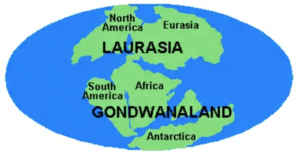
Earth of the present day is made up of six or seven continents and four or five oceans, depending on whom you ask. But this wasn’t always the case. Through the course of geologic time, the continents “drift” about on tectonic plates—large parts of Earth’s crust that float on a heated plastic layer of mantle and periodically crash into one another and break apart. Every so often (that is, every several hundred million years or so), the conditions are such that most or all of the continents come together to form a single larger landmass called a supercontinent. Notable supercontinents of the past include Laurasia, Gondwana (or Gondwanaland), and—the mother of all supercontinents—Pangea, which lasted from the early Permian Period (roughly 299 million years ago) into the early Jurassic Period (roughly 200 million years ago)

Dunia Ilivyokuwa hapo zamani Miaka 152 Milioni iliyopita. Kabla ya Mtengano wa Continents na Baharfi Wataalamu Wameyaita kwa majina kama vile Gondwana, Na Majina Mengineyo

Miaka Mbali Mbali na vipindi vyake. Vya Elimu ya Geology kama vile Permian, Triassic, Jurassic, Cretacious na Hivi sasa wakati tulionao Mamilioni ya Miaka iliyopita. Angalia Ardhi ilivyokuwa. Tunasoma kwamba Vipande vya Ardhi vinatembea na Kuyumbayumba. Je unaona Kuruani inathibitisha Sayansi za kisasa. Kwani Kuruani inasema kwamba Milima inayumbayumba kama vile Mawingu. Unaona Ukweli. Sayansi sasa inathibitisha Kuruani. Ikiwa Sahani za Ardhi zinayumbayumba basi Milima pia ipo juu yake zinayumba pamoja..Allahu Akbar.
 limezamishwana na lingine ju yake na Misukumano hiyo inasababisha Kuzuka na Kuua kwa Milima Juu ya Ardhi. Je uanona Milima inavyojengeka Juu ya Gamba la Ardhi. Allahu Akbar. Na milima hii inafanya kazi ya Kuzuia Plate Tectonics yaani Lithosphere zisigongane gongane na kuyumba yumba. Mwenyeezi Mungu amesema haya katika Aya nilizozitaja hapa Juu. Je onaona Neema alizotujaalia Mwenyeezi Mungu. Allahu Akbar.")
Pande la Sahani au Plate chini ya Ardhi (Lithosphere) limezamishwana na lingine ju yake na Misukumano hiyo inasababisha Kuzuka na Kuua kwa Milima Juu ya Ardhi. Je uanona Milima inavyojengeka Juu ya Gamba la Ardhi. Allahu Akbar. Na milima hii inafanya kazi ya Kuzuia Plate Tectonics yaani Lithosphere zisigongane gongane na kuyumba yumba. Mwenyeezi Mungu amesema haya katika Aya nilizozitaja hapa Juu. Je onaona Neema alizotujaalia Mwenyeezi Mungu. Allahu Akbar.

Picha ineyoelezes Ncha au Boundaries za Sahani au Plates za Gamba la Ardhi. Nimeelezea Habari za Boundary au Ncha za Sahani katika Maelezo hapa juu.

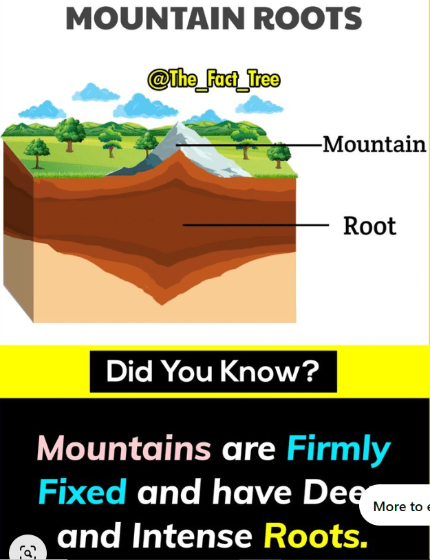
Milima na Mizizi mikubwa kama Kuruani ilivyosema kwamba Milima ni Kama Vigingi. Na kwa kawaida Vigingi chini ya Ardhi ni Virefu kuliko juu ya Ardhi. Ukijenga Hema basi utazamisha kigingi chini kwa urefu zaidi kuliko juu ili ulidhibiti hema lako vizuri zaidi.

Picha Ya Mlima na Mzizi Wake. Angalia Aya Ya kuruani hapa juu. Inathibitisha haya. Allahu Akbar. Unaona Maajabu. Kuruani imezungumza haya Katika Karne ya 7. Hata wanasayansi wa leo bado wanasoma na hawajui vizuri. Allahu Akbar.
